Tian, Zhang, Klein, Wang, Öktem, and Romps, Summertime continental shallow cumulus cloud detection using GOES-16 satellite and ground-based stereo cameras at the DOE ARM Southern Great Plains site, Remote Sensing, 2021
Paper
Description
With a spatial resolution of about half a kilometer, the relatively new GOES-16 weather satellite has the capability, at least in principle, to detect shallow cumulus clouds, whose sizes over the summertime continental United States are around 1 to 2 kilometers in width. This paper makes a first attempt at this and uses the Clouds Optically Gridded by Stereo (COGS) data to validate the results.
COGS uses six stereo cameras that we designed and that were deployed in Oklahoma by the Department of Energy. The COGS data comprises a four-dimensional grid of binary cloud/clear values at 50-meter and 20-second resolution. With a little bit of geometry, we can calculate what those clouds should look like to the GOES-16 satellite. This generates the COGS GOES emulator: a set of data that can serve a benchmark for any algorithm designed to detect shallow cumulus using the GOES-16 data. This paper confirms that we can, indeed, identify shallow cumulus using the GOES-16 satellite, opening the door to a new data stream for the study of cloud dynamics and their radiative impacts.
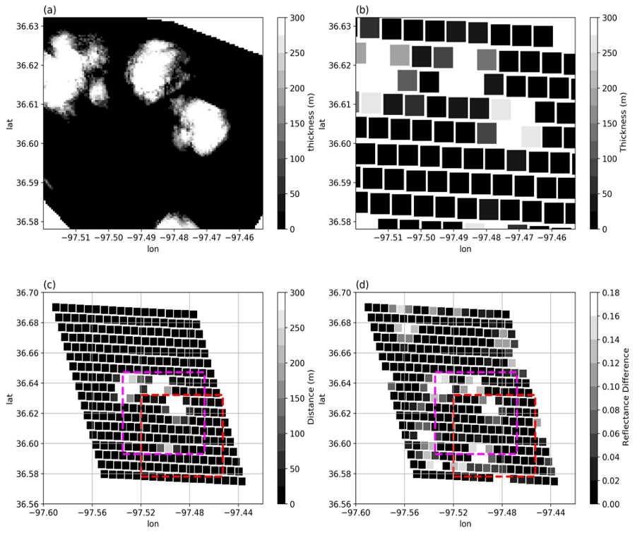
(a) Cloud thickness from COGS on 20:33:40 UTC July 11th, 2018. (b) The COGS data from (a) regridded to the same resolution of GOES. (c) The COGS data passed through the GOES-16 emulator, i.e., the mean distance through clouds observed by stereo cameras (the COGS data) along the path from GOES-16 satellite to the GOES surface pixel. (d) Reflectance difference from GOES data, which is the difference between GOES reflectance and clear-sky surface reflectance.